搜索结果: 1-15 共查到“工学 Change”相关记录517条 . 查询时间(0.25 秒)

An interdisciplinary approach to fighting climate change through clean energy solutions(图)
清洁能源 气候变化 电池 脱碳电网
2023/6/20


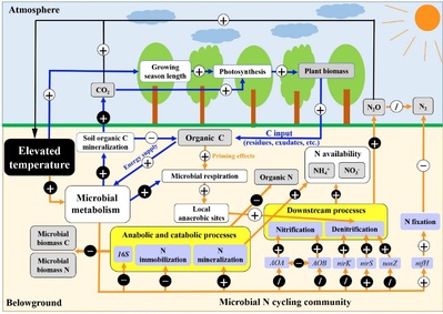
浙江大学环境与资源学院徐建明教授团队在Global Change Biology发文揭示升温对全球陆地生态系统氮素转化的影响规律和碳氮耦合机制(图)
浙江大学环境与资源学院 徐建明 全球陆地生态系统 氮素转化 影响规律 碳氮 耦合机制
2020/7/16
2020年7月2日,环境与资源学院徐建明教授团队在国际权威期刊Global Change Biology在线发表了题为“Elevated temperature shifts soil N cycling from microbial immobilization to enhanced mineralization, nitrification and denitrification acros...

北京大学国际关系学院博士后王彬彬在环境/大气领域国际一流期刊WIREs Climate Change发表论文(图)
北京大学国际关系学院 博士后 王彬彬 环境/大气 一流期刊 WIREs Climate Change
2020/4/22
2020年4月9日,我院博士后王彬彬(第一作者)在国际一流SCI/SSCI双收录期刊Wiley Interdisciplinary Reviews(WIREs) -Climate Change(WIREs Climate Change)发表题为“Climate change in the Chinese mind: An overview of public perceptions at macr...

Nature Climate Change刊发深海圈层与地球系统前沿科学中心最新研究成果(图)
Nature Climate Change 中国海洋大学深海圈层与地球系统前沿科学中心 北太平洋副热带模态水 大西洋多年代际变化 海洋气候
2020/2/19
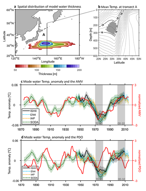
2020年2月17日,国际顶级学术期刊Nature(《自然》)子刊Nature Climate Change(《自然气候变化》)在线发表了题为“North Pacific subtropical mode water is controlled by the Atlantic Multidecadal Variability”(《北太平洋副热带模态水受大西洋多年代际变化控制》)的最新研究成果。该成...

Grid reliability under climate change may require more power generation capacity(图)
Grid reliability climate change power generation capacity
2019/12/6
NSF-funded researchers are using a new modeling approach for infrastructure planning of a long-term electricity grid that considers future climate and water resource conditions. Those conditions incl...

中国科学院地理科学与资源研究所吴朝阳、王焕炯、葛全胜等在Nature Climate Change发表秋季物候变化最新成果(图)
中国科学院地理科学与资源研究所 吴朝阳 王焕炯 葛全胜 Nature Climate Change 秋季物候变化
2018/12/19
植被是陆地生态系统的重要组成部分,在全球变化碳循环研究中扮演着重要的角色。物候变化和碳循环年际变化密切相关,是众多生态系统模型的一个重要参数,因而也是全球变化领域的一个研究热点。现有物候变化研究大多关注植被春季物候变化,如展叶期、开花期等,对秋季物候变化的机制分析略显滞后,其模拟方法一般难以得到较高的精度。中科院地理资源所吴朝阳研究员、王焕炯副研究员、葛全胜研究员联合美国、欧洲等国家的全球变化领域...
MULTITEMPORAL ANALYSIS OF FOREST COVER CHANGE USING REMOTE SENSING AND GIS OF KANHA TIGER RESERVE, CENTRAL INDIA
Forest LULC Livelihood Climate Change Adaptation
2019/2/27
Forest ecosystems play a key role in global ecological balance and provide a variety of tangible and intangible ecosystem services that support the livelihoods of rural poor. In addition to the anthro...
SAR COHERENCE CHANGE DETECTION OF URBAN AREAS AFFECTED BY DISASTERS USING SENTINEL-1 IMAGERY
SAR Coherence Change Detection Coherence maps Hurricane earthquake
2018/5/15
The study focuses on two study areas: San Juan in Puerto Rico, which was affected by Hurricane Maria in September 2017, and Sarpol Zahab in Iran, which was one of the towns affected by an earthquake i...
INFRARED ROTATION PLANE RADAR CHANGE DETECTION
Infrared Rotation Plane Radar Change Detection Depth Information Mixed Gaussian Background Modeling
2018/5/15
The existing change detection method mainly stays on the pixel-level, which is very susceptible to light, shadow, etc. And the complex calculation and analysis for each pixel reduce the detection effi...
CHANGE DETECTION IN HIGH-RESOLUTION REMOTE SENSING IMAGES USING LEVENE-TEST AND FUZZY EVALUATION
High-resolution images change detection Levene-Test hue-texture features fuzzy evaluation method
2018/5/15
High-resolution remote sensing images possess complex spatial structure and rich texture information, according to these, this paper presents a new method of change detection based on Levene-Test and ...
CHANGE DETECTION OF HIGH-RESOLUTION REMOTE SENSING IMAGES BASED ON ADAPTIVE FUSION OF MULTIPLE FEATURES
Change Detection Color Gistogram Linear Gradient Histogram EMD distance Histogram Curvature
2018/5/15
In view of the traditional change detection algorithm mainly depends on the spectral information image spot, failed to effectively mining and fusion of multi-image feature detection advantage, the art...
LANDSLIDE INVENTORY MAPPING FROM BITEMPORAL 10 m SENTINEL-2 IMAGES USING CHANGE DETECTION BASED MARKOV RANDOM FIELD
Landslide Inventory Mapping Change Detection Normalized Difference Vegetation Index Principal Component Analysis Markov Random Field Sentinel-2 Images
2018/5/15
Landslide inventory mapping is essential for hazard assessment and mitigation. In most previous studies, landslide mapping was achieved by visual interpretation of aerial photos and remote sensing ima...
STUDY ON THE COASTLINE CHANGE OF JIAOZHOU BAY BASED ON HIGH RESOLUTION REMOTE SENSING IMAGE
Jiaozhou Bay Coastline Increase Decrease Rate
2018/5/17
In recent years, with the rapid development of the Jiaozhou Bay area of Qingdao, the influence of human activities on the coastline of Jiaozhou Bay is becoming more and more serious. Based on the high...


