搜索结果: 1-15 共查到“工学 City”相关记录303条 . 查询时间(0.234 秒)
Researchers used the City of Pittsburgh to create a model built upon the design, materials and purpose of commercial buildings to estimate their energy usage and emissions.

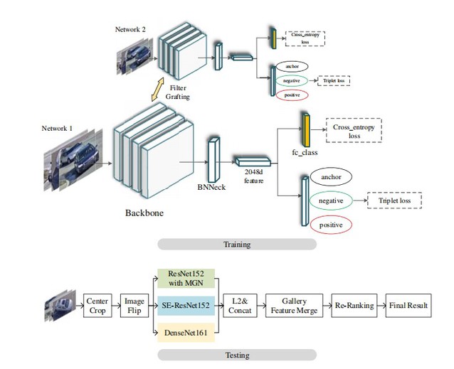
中国矿业大学计算机科学与技术学院团队在CVPR Workshop 2020 AI CITY竞赛中荣获全球第五(图)
中国矿业大学计算机科学与技术学院 CVPR Workshop 2020 AI CITY 全球第五
2020/7/2
近日,由IEEE国际计算机视觉与模式识别会议(CVPR)Workshop主办的“智能交通视频分析界的ImageNet竞赛”——英伟达智慧城市挑战赛(AI CITY CHALLENGE 2020)落下帷幕。我校计算机学院周勇教授、姚睿副教授和赵佳琦副教授指导,由硕士生高存远等组成的竞赛团队BestImage获得赛道二:城市级规模的多摄像头下的车辆重识别竞赛(City-Scale Multi-Came...

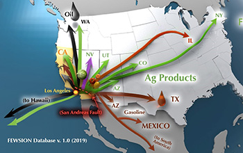
Data scientists map the supply chains of every U.S. city(图)
Data scientists supply chains U.S. city
2019/10/30
No matter where you live in the United States, some food in your kitchen probably started its life in California's agricultural fields.How do you know? Vegetables, like every other product, follow a s...
KNOWLEDGE-BASED FRAMEWORK FOR AUTOMATIC SEMANTISATION AND RECONSTRUCTION OF MILITARY ARCHITECTURE ON CITY-SCALE MODELS
city-scale model knowledge-based modelling architectural heritage
2019/3/2
The scale models of fortified towns belonging to the Plans-Reliefs collection are exceptional witnesses of the formation of the French territory. The aim of the URBANIA project is the valorisation and...
1D-2D MODELING OF URBAN FLOODS AND RISK MAP GENERATION FOR THE PART OF HYDERABAD CITY
Stormwater Urban Flood Modeling Zone XIII SWMM PCSWMM
2019/2/27
Space for water is now becoming guiding principle of urban planning because urban flooding is the major problem facing by most of the cities in India. Urban development in developing countries like In...
SEMANTIC MODELING OF UTILITY NETWORKS IMPLEMENTATION OF USE CASES FOR DEHRADUN CITY
OGC CityGML data model Utility Network ADE data storage utility infrastructure use cases
2019/2/27
The current on-going boom in the field of Building Information Modeling (BIM) and 3D GIS is widely being explored for vast urban related applications, analyses and simulations. Large amount of 3D city...
DENDROGRAM CLUSTERING FOR 3D DATA ANALYTICS IN SMART CITY
Smart City Dendrogram Clustering 3D Spatial Database 3D GIS Data Analytics Data Structure
2018/11/9
Smart city is a connection of physical and social infrastructure together with the information technology to leverage the collective intelligence of the city. Cities will build huge data centres. Thes...
ESTIMATION OF PM2.5 VERTICAL DISTRIBUTION USING CUSTOMIZED UAV AND MOBILE SENSORS IN BRGY. UP CAMPUS, DILIMAN, QUEZON CITY
Unmanned Aerial Vehicle Air Quality Quezon City Monitoring Particulate matter (PM) Concentration PM2.5 Meteorological Parameters
2018/11/8
As the unmanned aerial vehicle (UAV) technology has gained popularity over the years, it has been introduced for air quality monitoring. This study demonstrates the feasibility of customized UAV with ...
DESIGNING PRECINCTS IN THE DENSIFYING CITY – THE ROLE OF PLANNING SUPPORT SYSTEMS
Data-driven approaches Geographic Information Systems (GIS) Collaborative planning Medium density Digital-planning tools
2018/11/9
Australia’s cities face significant social, economic and environmental challenges, driven by population growth and rapid urbanisation. The pressure to increase housing availability will lead to greate...
URBAN HEAT ISLAND MICRO-MAPPING VIA 3D CITY MODEL
Urban Heat Island 3D City Models 3D Solar Analysis
2018/11/9
Urban Heat Island (UHI) phenomenon has been a topic of intense study over the past several years. However, to visualise UHI model is still an issue. Common visualisation of UHI by using digital themat...
COMBINING URBAN METABOLISM METHODS AND SEMANTIC 3D CITY MODELS
Stocks and Flows, Urban Metabolism 3D City Model CityGML General Indicator Model GIM Dynamizer
2018/11/9
he last decade has witnessed increasing interest in the study of urban stocks and flows. This paper provides a literature review for different studies of urban stocks and flows. The review shows that ...
VISIBLE ROUTES IN 3D DENSE CITY USING REINFORCEMENT LEARNING
3D GIS Visibility Routes Reinforcement learning
2018/11/9
In the last few years, the 3D GIS domain has developed rapidly, and has become increasingly accessible to different disciplines. 3D Spatial analysis of Built-up areas seems to be one of the most chall...
GEO-C: ENABLING OPEN CITIES AND THE OPEN CITY TOOLKIT
Open cities Smart cities GIScience participation transparency Open City Toolkit, doctoral programme GEO-C
2018/11/8
The GEO-C doctoral programme, entitled “Geoinformatics: Enabling Open Cities”, is funded by the EU Marie Skłodowska-Curie actions (International Training Networks (ITN), European Joint Doctorates...
CITY-LEVEL ADULT STROKE PREVALENCE IN RELATION TO REMOTE SENSING DERIVED PM2.5 ADJUSTING FOR UNHEALTHY BEHAVIORS AND MEDICAL RISK FACTORS
PM2.5 stroke remote sensing health effect air pollution
2018/5/14
This research explores the use of PM2.5 gird derived from remote sensing for assessing the effect of long-term exposure to PM2.5 (ambient air pollution of particulate matter with an aerodynamic diamet...
THE RESEARCH AND EVALUATION OF ROAD ENVIRONMENT IN THE BLOCK OF CITY BASED ON 3-D STREETSCAPE DATA
3D streetscape data block unit urban assessment model street environment traffic environment urban plan
2018/5/14
This paper focus on the problem of the street environment of block unit, based on making clear the acquisition mode and characteristics of 3D streetscape data,the paper designs the assessment model of...

